University geophysics faculty and students were fortunate to observe the unexpected recent eruption of a long-dormant volcano on the uninhabited island Anatahan, part of the U.S.-administered Commonwealth of the Northern Marianas in the western Pacific.
A seismograph they had deployed on Anatahan, about 200 miles north of Guam, only a few days before the eruption captured a trove of important seismic data — a detailed chronology of pre- and post-eruption rumblings.
“It is possible that this information could prove valuable in the development of models for more accurate prediction of future volcanic eruptions and other seismic activity in the region, which is one of the world’s most active areas,” said Patrick Shore, Ph.D., a research scientist and lecturer in earth and planetary sciences in Arts & Sciences.
The University research team, headed by Douglas Wiens, Ph.D., professor of earth and planetary sciences, is working with collaborators from the Scripps Institution of Oceanography and the Saipan Emergency Management Office (EMO) to install earthquake sensors in the Northern Marianas for an experiment funded by the National Science Foundation (NSF).
Designed to study the source regions of magma that erupts from the Mariana island arc, the joint U.S.-Japan Mariana Subduction Imaging Experiment requires the deployment of 20 land seismographs and 58 ocean-bottom seismographs.
Shore directed the installation of seismographs on various Mariana islands with assistance from University graduate students Brian White and Sara Pozgay. While the team’s primary focus is exploring the tectonic forces in the region, the chance capture of detailed volcanic eruption data may offer new avenues of research, perhaps providing tools to help access volcanic and seismic hazards to the people of the Marianas.
“We were able to capture a few days of data from the quiet period before the eruption, which is important for comparison purposes, and we have been capturing excellent data on the eruption ever since,” Shore said.
The people of the Northern Marianas have been anxious for improved seismic monitoring systems since 1981, when the eruption of another volcano on the island of Pagan forced many residents to migrate into the urban center of Saipan. Before the Anatahan eruption, pressure had been mounting for the government to authorize the resettlement of islands previously ruled off-limits due to a threat of volcanic activity.
The Northern Mariana island chain lies adjacent to the Mariana trench, the deepest place on the surface of the Earth. The islands are exposed volcanoes that form due to the subduction of the Pacific Plate beneath the Philippine Plate.
The Northern Mariana islands were of great strategic importance during World War II, when the United States gained control of them. In 1978, residents of the islands voted to form a commonwealth in political union with the United States; they are U.S. citizens but do not vote in federal elections.
A historic first
Anatahan is a tiny island with a rugged, densely vegetated landscape dominated by a large volcanic crater. White and Allan Sauter, Ph.D., a seismology specialist at the Scripps Institution of Oceanography in San Diego, had no clue that an eruption was imminent when they were dropped off on the island the morning of May 6.
The research team’s base ship, the Super Emerald, then traveled two-and-a-half hours to the nearby island Sarigan to drop off Shore, Pozgay and other team members. If the volcano had erupted while White and Sauter were on Anatahan, they would have been stuck there until the ship could return.
“When the volcano erupted, winds pushed most of the ash and debris toward the western side of the island where we had installed the seismograph,” White said. “If we had been trapped there, we would have probably tried to make our way to the other side of the island.
“Since the jungle is very thick, it would have been almost impossible to make our way around over land. We happened to have snorkeling gear with us, so our best bet might have been to swim around to the other side.”
After installing the Anatahan equipment, the NSF team spent four days traveling on Super Emerald and deploying stations on five other islands. Then, on the evening of May 10, as the team cruised back toward home base in Saipan, the researchers witnessed brilliant bursts of lightning above Anatahan.
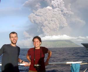
As dawn broke, the small crew of researchers was astounded to see a pillar of volcanic ash and steam billowing some 30,000 feet above the shoreline. They were witnessing the first eruption in recorded history of the Anatahan volcano.
Pozgay was the first team member to notice lightning from the eruption.
“It was the most amazing thing I’ve ever seen in my life,” Pozgay said later in an interview with The Associated Press. The incredible lightning display, she told the AP, was caused by movement among particles swirling in the towering volcanic clouds.
Just before dawn, it became clear to Pozgay that Anatahan was actually erupting. Jose Kaipat, an EMO seismologist, woke the rest of the team with the exciting news. Cameras in hand, they hurried on deck to glimpse the natural spectacle.
As the researchers watched the volcano rage, they realized that the seismograph installed on Anatahan just days before might now be capturing important seismic data. If recoverable, the data might help EMO seismologists seek better methods of predicting where and when the next deadly eruption might strike the Marianas.
The waiting game
The big question: Had the Anatahan seismograph survived the blast?
The station’s state of health is relayed, via satellite, back to the United States. Although no seismic data is transmitted, the station does sporadically report whether it is still working. These reports were received by the team in Saipan a few days after their return from the deployment trip.
The first report indicated, surprisingly, that the station was still running and collecting data. They could tell that the station was running low on power, because the solar panels were covered with volcanic ash. However, no sense of whether the sensor itself was still working was sent, and it was not known if the data being recorded was valid and usable.
Although anxious to return to Anatahan, researchers were forced to play a waiting game. The volcano gained force, making it impossible for anyone to set foot on the island for several days.
“The emergency management officials were very interested to learn that we had visited the island just days before the eruption because we could confirm that the island was indeed uninhabited at the time of the eruption,” White said. “Otherwise, emergency officials would have been forced to consider sending rescue teams to the island during a very dangerous phase of the eruption.”
Shore, Pozgay and White waited in Saipan, the main urban center of the Marianas, where they were soon joined by Wiens, who had just installed seismographs on Guam. Hoping to gain some sense of the Anatahan seismograph’s fate, Wiens arranged to fly along on an emergency management helicopter mission over the island May 13.
From the air, it was clear Anatahan had been hit hard — about six inches of volcanic dust and debris already covered the small, uninhabited village where the seismograph had been deployed. Luckily, the eruption produced no lava, so the only hazard to the seismic station was the blanket of ash, which blocked the solar panels and cut off its source of power.
“The island was still erupting, but with less intensity than on May 11,” Wiens said. “Large boulders (volcanic bombs) were observed flying high in the air over the crater region. The whole western side of the island was now covered with ash, including the seismograph site.”
The helicopter was unable to land on Anatahan due to the danger posed by the loose ash. It did land on nearby Sarigan and recover data from a seismograph deployed there.
Preliminary analysis of the Sarigan data revealed that the Anatahan eruption was preceded by intense seismic activity starting at 1 p.m. local time May 10. The eruption probably began around 9 p.m. that same day.
More than a week passed before Super Emerald was able to return to the island with Shore, two vulcanologists and three representatives from the local emergency management office. The vulcanologists had flown from the United States on the chance that there would be an opportunity to visit the island.
Because the volcano was still erupting and a typhoon was thought to be approaching, the team was motivated to work quickly. They managed to dig out the station, recover the data, clear the solar panels and steepen the angle of the solar panel brackets. The hope was that with a steeper angle, the typhoon rains would wash the still-accumulating ash from the solar panels.
Shore’s visit revealed that the seismic station had not suffered any damage, and the highly sensitive sensor was still collecting good, quality data. Wiens got the good news May 21.
“They got all the volcanic ash off of our instrument and found it has been working fine (on its batteries) the whole time,” Wiens said. “We have great seismic recordings of the entire eruption.”
Since the eruption, the research team has been working closely with Mariana emergency management officials to make use of eruption data now in hand and to plan for the re-deployment of an extensive real-time seismic monitoring system on the islands.
Ironically, the commonwealth had previously installed such a system on Anatahan and other islands in the chain, but it was disabled last year due to a lack of funding. Thus, the seismographs installed for the NSF experiment are the only ones to have captured vital data on the recent eruption.
While much analysis remains to be done, White is optimistic that data captured by the team’s seismographs could eventually help develop an eruption early warning system for Anatahan and similar islands in the chain.
“We think it’s possible that it may someday be possible to monitor seismic activity and provide advance warning that an eruption is imminent,” he said.
If so, the residents who once inhabited Anatahan and the neighboring volcanic islands may one day be able to return to their homes and live with at least some sense of safety.