What Caused the Midcontinent Rift?
17:38 minutes
The Midcontinent Rift is an ancient rift system that could have split the country into two parts a billion years ago. In this live interview at the Sheldon Concert Hall in St. Louis, geologist Michael Wysession discusses how seismologists are using data from earthquakes and gravity measurements to characterize this underground geological scar. He explains why the rift stalled out and what this reveals about plate tectonics.
Michael E. Wysession is a Professor of Earth and Planetary Sciences at Washington University in St. Louis, and author of numerous science textbooks. He’s based in St. Louis, MO.
IRA FLATOW: This is Science Friday. I’m Ira Flatow coming to you from The Sheldon concert hall in St. Louis, Missouri.
[APPLAUSE]
St. Louis, as everybody knows, is located right in the Midwest, nearly in the center of the country. But things could have been different. There’s an ancient fault line that could have split the continent. It could have created an ocean along your northern neighbors around present day Minnesota and Wisconsin. My next guest is trying to uncover signs of this fractured geological past. He’s part of a team creating a sort of telescope to peer underground with an interesting set of tools. He’s using earthquakes and gravity.
And we’re going to test one of these out in a little bit. And if you want to participate in our little experiment right now, take out your smartphones. You can download an app to your smartphone called iSeismometer. Now, both the iPhone and Android versions of this, we’re going to do a little experiment with it later.
So just let’s move along with that. Michael Wysession is a professor of Earth and Planetary Sciences at Washington University here in St. Louis. Welcome to the program.
MICHAEL WYSESSION: Thank you very much, Ira.
[APPLAUSE]
It’s a real honor to be on your show.
IRA FLATOW: Tell us about this ancient fault line. Where is it? And how do we know it exists? Why are you interested in it? Pick any one of those questions.
MICHAEL WYSESSION: Absolutely. So you know, geologically, people usually think that the action happens on the edges of the continents. Right? If you want to find an earthquake in the United States you go to San Francisco or Seattle or Alaska. But 1.1 billion years ago, this was the center of attention here. And there was a massive rift. It actually extended from Oklahoma all the way up to Canada and back down again through Illinois and Indiana.
And at this time, this was the African Rift Valley of its age. The continent was splitting apart. And the crust was thinning. And something unusual happened though. There seemed to have been a hotspot in the region like what’s causing all the volcanoes in Hawaii. It seems to be a rare combination of a rifting, a splitting apart, of a continent with a hotspot. And you released, at this time, two cubic million kilometers of lava.
IRA FLATOW: Wow.
MICHAEL WYSESSION: And this far dwarfs anything that we have seen in the last tens of millions of years.
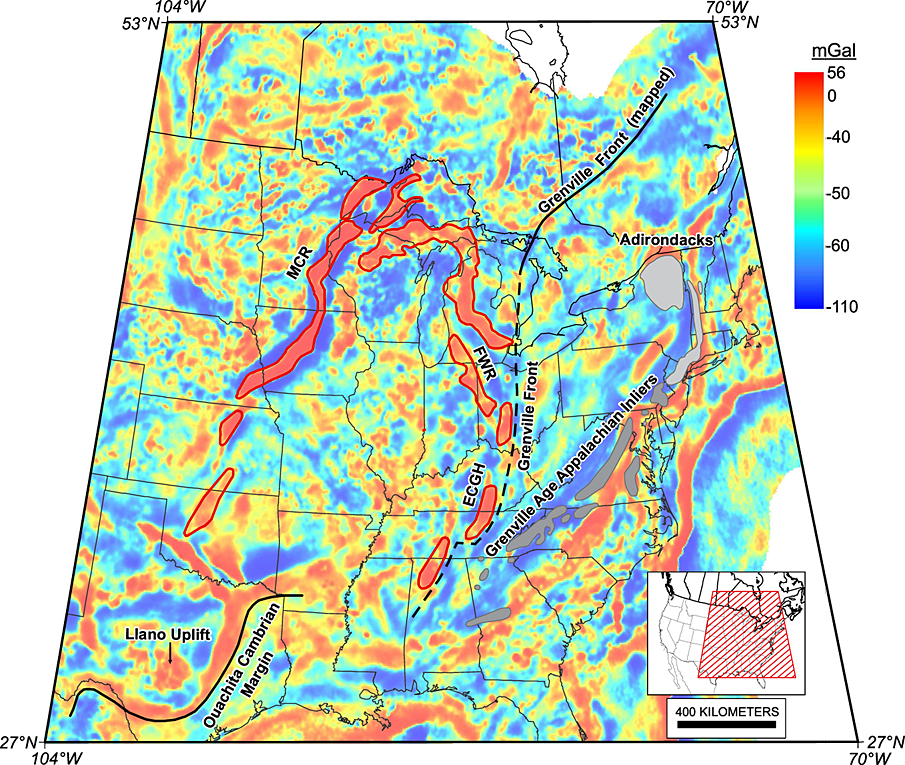
IRA FLATOW: As I mentioned before, you use the earthquakes themselves and gravity to map the fault lines. There’s a gravity map of the US right there on the screen behind us. What areas have different gravity measurements from one to the other? How do we interpret what we’re seeing on that map?
MICHAEL WYSESSION: So essentially, usually, in this map, places that are purple– and the line in the center of the image here, that purple line represents a high gravity anomaly. That means– you may not realize this, but the pull of gravity actually varies slightly as you move about Earth’s surface. It’s a result in changes in density of the rock underneath you. Now, normally, when you cross a rift like the African Rift Valley, your gravity is a little bit weaker because you’ve stretched and thinned the crust, and you filled it in with sediments, which are less dense.
This scar is just the opposite. It’s a gravity high. Gravity pulls you a little bit more. And it’s because there are 20 kilometers deep of basaltic lava that filled in this rift. In fact instead of the crust being thin, the crust is actually 20 kilometers thicker than normal because of this massive amount of lava that filled in.
IRA FLATOW: And lava has got iron, rich in iron and things like that that affect the magnetic fields and gravity, stuff like that?
MICHAEL WYSESSION: Yes, when you have lava and then you have hot fluids that flow through, often for millions of years, you do some interesting things. This actually is important for the history of our country because this is the largest reserves of pure copper anywhere in the world.
IRA FLATOW: That’s why it’s there.
MICHAEL WYSESSION: And it’s these hot fluids flowing through the basaltic lava pulled out metals that don’t like to fit in the crystal structure of rock very well. The mines along here in Minnesota and Wisconsin really fed our industrial revolution.
IRA FLATOW: It’s like where you have the Iron Range of Minnesota?
MICHAEL WYSESSION: That’s exactly where it came from.
IRA FLATOW: That’s where all that stuff came from. So these gravity anomalies help to pinpoint what you’re calling the Midcontinental Rift. I don’t think we’ve ever heard it talked about that way.
MICHAEL WYSESSION: Yeah, so St. Louis, we have a different idea of a rift here, right, because we have the real–
IRA FLATOW: We’re not talking political rift here.
[LAUGHTER]
MICHAEL WYSESSION: Yeah, it’s not the Mason-Dixon Line. It’s the other direction. Its a north-south trending rift. And we have earthquakes around here. And that’s a result of the fact that there was another rift here 750 million years ago, the Reelfoot Rift, where the crust was also thin. Only, it’s actually a zone of weakness in the crust, so as stresses occur, you get earthquakes along in places like New Madrid.
This Midcontinent Rift is like a scar that’s healed over with very thick scar tissue. It’s actually stronger than the surrounding crust. So it has no earthquakes. We actually had a set of seismometers up here for two years. We recorded thousands and thousands of mine and quarry blasts. We recorded 12 earthquakes that were about a magnitude one in size, which is essentially nothing. So this region has no earthquake because it’s so healed over by the thick lava that filled it in.
IRA FLATOW: Well, then, now that you see the gravity part, how do you use the earthquakes? You mentioned that we’ve had earthquakes here. How do you use the earthquakes to fill in the rest of the picture?
MICHAEL WYSESSION: So actually, we use earthquakes from other parts of the world. And you mentioned the seismometer. We can’t see through rock. Right? This is a problem that geologists have had for centuries. I can point a telescope in the sky. I can see galaxies billions of light years away. I can’t tell you what’s a foot beneath the ground. But we can hear what’s in the Earth.
My wife’s a veterinarian. She uses a stethoscope to hear what’s inside an animal. I have a seismometer that I can use to hear what’s inside the planet. And anything in the planet that makes noise, human-generated or Earth-generated, makes a sound. And so we listen to the earthquakes arriving from around the world coming up underneath our network of seismometers. And it allows us to make 3D images, much like a sonogram does.
IRA FLATOW: And that’s why I asked you to download the app, iSeismometer, because we’re going to do a little seismic experiment right now. Aren’t we? Tell people what we’re going to do.
MICHAEL WYSESSION:, OK, so this is a typical seismogram. There’s a lot going on here. First of all, there are three components because we live in a three-dimensional spatial universe. So there’s up-down, left-right, and front and back.
And if you look at the iSeismometer app, there are many good phone apps that have seismometers. I like this one in particular because it does give you all three components. And if you shake it different directions, you can see different of the three seismograms actually vibrate.
And I have a demonstration here using a program called Quake-Catcher Network, which was designed to actually record people’s laptops from around the world. There have been cases where an earthquake has been recorded by essentially a majority of Starbucks in the country.
[LAUGHTER]
You can upload your signal from your laptop to this centralized location.
But what I have here is actually an accelerometer, a type of seismometer, that is plugged in through the USB port. And this is a great tool, by the way, for teachers. It’s used in classrooms across the country. You can demonstrate how an earthquake operates.
To give you a sense of the sensitivity though, if I just stomp from here–
[STOMPS FOOT]
–you can see I totally swamped the signal there.
IRA FLATOW: I even got it on my app registry.
MICHAEL WYSESSION: And I want to do a little bit of an experiment here. I would like everyone on the left side to stomp their feet at the same time. One, two, three, stomp.
[STOMPING]
OK, wow, that was pretty impressive. All right, let’s try the right side here. One, two, three, stomp.
[STOMPING]
That’s about the same size, maybe a little bigger. All right, now the central part. One, two, thre stomp.
[STOMPING]
IRA FLATOW: Wow. Went off the scale.
MICHAEL WYSESSION: I don’t know if this is going to work, but I want everyone in the balcony.
[AUDIENCE SHOUTING]
We’ll see. Now, the signal, the vibration, is going to have to come down through the walls I don’t know that this is going to work. But we’ll give it a shot. One, two, three–
[STOMPING]
IRA FLATOW: Whoa.
MICHAEL WYSESSION: There it is. You caused the whole building to shake. And we recorded it up here on the seismometer.
Now, the seismometers we use for our research are so sensitive, we record small earthquakes in New Zealand or Japan or anywhere around the world. And so that gives us the ears to the ground that we use to make three dimensional images of what the Earth is made of. And that tells us how plate tectonics works, and how the Earth is moving.
IRA FLATOW: This group of sensors that you have around, did they reveal anything about the geology of the Midcontinent Rift?
MICHAEL WYSESSION: What we notice– and in this diagram, the left hand, you see the location of the seismometers. Our deployment of over 80 seismometers was timed with a project called Earthscope, which was a fabulous National Science Foundation project that involved moving an array of 400 seismometers slowly, sweeping across the country over 10 years. And actually, now, it’s been moved off to Alaska.
And so we had a large number of seismometers. And the images on the right show the depth of what’s called the Moho, which is actually named after Andrija Mohorovičić. We can never pronounce his name. So we call it the Moho. It’s the boundary between the crust and the mantle. And this boundary is normally about 40 kilometers beneath continents, 40 to 45 kilometers.
Beneath the Midcontinent Rift, we see that dropping down to more than 60 or 65 kilometers, more than 20 kilometers thicker than usual. And that’s due to the unique history. Or as the crust rifted and thinned, lava began pouring in, which was heavy and pushed, depressed it down, which left room for more lava to flow in. And by the time the process was entirely done, you have, as I said, more than 20 kilometers worth of lava.
IRA FLATOW: I’m Ira Flatow. This is Science Friday from PRI, Public Radio International. Talking with Michael Wysession about a clinic he’s conducting in earthquakes and seismology and how to detect them.
We have someone in the audience here. Yes.
SPEAKER 1: Fracking in Oklahoma, does it affect the crust that was built from the basalt lava?
IRA FLATOW: The fracking in Oklahoma, what relationship does it have to the earthquake?
MICHAEL WYSESSION: So yes, thank you for that question. It used to be that the earthquake capitals of the US were California and Alaska. That is no longer the case. The earthquake center of the US is, in fact Oklahoma. It used to get one or two magnitude 3 earthquakes a year. It now gets over 1,000. And this is entirely due to the pumping of fracking fluids back into the ground.
Now, interestingly, it’s not the fracking process itself that generates the earthquakes. But it’s taking these fracking fluids, which are often toxic and cannot be left at the surface, and pumped down deep about five kilometers. And in the process, it actually lowers the pressure across the fault.
Let me give you an example. Would you put your hands together lightly. And now, slide your right hand up. OK? So just slide it up like this. OK, that’s an earthquake. And at the surface, it happens fairly easily.
Now, I want you to push as hard as you can across your two hands. Now, try to slide your right hand up. You can’t do it. That’s deep in the ground. The pressure keeps the fault closed and prevents earthquakes from happening. Now, pump some lubricant, oily fluid in between your hands, and [CLICKS TONGUE] that earthquake will happen.
So it only happens where you have preexisting faults. And so these are old faults. Again, the continent is more than a billion years old there. But the faults are generally not active. However, when you pump the fracking fluid in and you happen to hit a fault, you will then generate earthquakes.
IRA FLATOW: It’s lubricating. Lubricating that spot?
MICHAEL WYSESSION: Exactly.
IRA FLATOW: So when we had all the fault line there, why are we now not on beachfront property like there would be in California or whatever?
MICHAEL WYSESSION: Well, so that’s a question that, actually, colleagues at Northwestern the University of Illinois have been working on. And it seems like right about this time, what is now the Amazon Basin of South America– we called it at that point, Amazonia– was sliding past the southern part of what is now the United States. And while it was sliding past, this is when the rifting across the Midcontinent Rift occurred.
As soon as it broke away and the ocean started opening there between North America and Amazonia, that relieved the stress that was pulling our rift apart. And our rifting stopped there. So if it hadn’t been for South America, we would now be in two pieces. So we owe Brazil a great debt.
IRA FLATOW: All right, thank you. We’ll all keep that in mind. Thank you. Fascinating, Michael. Thank you very much for joining us.
[APPLAUSE]
Michael Wysession, Professor of Earth and Planetary Sciences at Washington University in St. Louis.
[APPLAUSE]
That’s about all the time we have. There are certain people we’d like to thank– Tim [? Ebee, ?] Eli Chen, Phil Donato, Rachel [INAUDIBLE], Tim Albert, and Paul [? Reuter, ?] and all the great folks at St. Louis Public Radio. We also want to thank The Sheldon concert hall here, this beautiful place, for making this wonderful evening possible.
We also want to thank Kevin Buckley, Ian Walsh, and Moan Abdulla Grays. And we cannot forget our Science Friday staff, Charles Bergquist, Rachel Bouton, Daniel Dana, Brandon Echter, Elah Feder, Jennifer Fenwick, Xochitl Garcia, Sarah Goldfarb, Luke Groskin, Katie Hiler, Christopher Intagliata, Jen Kwak, Juile Leibach, Alexa Lim, Annie Minoff, Annie Nero, Daniel Peterschmidt, Christian Skotte, Christie Taylor, Chau Tu, and Ariel Zych. Thank you all for allowing us to do this. From St. Louis, Missouri, I’m Ira Flatow.
[APPLAUSE]
[FIDDLE MUSIC PLAYING]
Copyright © 2016 Science Friday Initiative. All rights reserved. Science Friday transcripts are produced on a tight deadline by 3Play Media. Fidelity to the original aired/published audio or video file might vary, and text might be updated or amended in the future. For the authoritative record of ScienceFriday’s programming, please visit the original aired/published recording. For terms of use and more information, visit our policies pages at http://www.sciencefriday.com/about/policies/
Alexa Lim was a senior producer for Science Friday. Her favorite stories involve space, sound, and strange animal discoveries.