University earth and planetary scientists are paving the way for a smooth Mars landing for the Phoenix mission — scheduled to launch in August — by making sure the set-down literally is not a rocky one.
A team led by Raymond E. Arvidson, Ph.D., the James S. McDonnell Distinguished University Professor and chair of earth and planetary sciences in Arts & Sciences, has analyzed images taken from a NASA instrument to make sure the Phoenix spacecraft lands in a spot on the Red Planet’s northern plains that is relatively rock-free.
“The craft has to land in a place unlikely to have slopes more than 16 degrees relative to horizontal, and it shouldn’t have very many rocks higher than 30-40 centimeters,” or roughly one foot high, Arvidson said.
“We’ve been looking for locations big enough and homogeneous enough for a high probability of a successful landing. The issue isn’t slopes. The issue is rocks.”
If the lander came down in an area with rocks roughly the same size as the lander or larger, the whole craft could tilt or tip over.
Rocks could also impede the craft’s solar panels; large rocks would prevent the unfurling of the craft’s solar panels, which are circular and rotate open. Solar power drives seven Phoenix mission instruments. Without it, there isn’t much of a mission, which aims to have the lander use a robotic arm to dig down to a layer containing water ice and gather samples of soil and ice in the continuing pursuit of water on Mars.
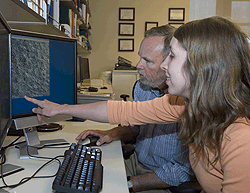
The lynchpin of the meticulous, painstaking landing-site locator task is earth and planetary sciences junior Tabatha Heet, who began working on the project in October.
“Ray asked if I would count some rocks in the original landing area, and I got started, thinking it was going to be a one-time thing,” said Heet, a student in the acclaimed Pathfinder Program, a challenging, interdisciplinary curriculum with an environmental emphasis. “But it’s turned into a big project. I’ve counted thousands of rocks now.”
Heet gets large images from the High Resolution Imaging Science Experiment (HiRISE) camera, a feature of the Mars Reconnaissance Orbiter mission, which permits viewing rocks as small as a yard across.
Before HiRISE images were available, Arvidson and his colleagues settled on a region called Region B for the future landing.
“The first images for Region B were scary,” Arvidson said. “There are rocks there bigger than the lander — too many big rocks sitting on craters to fit in a landing site.”
Studying the HiRISE images, the team looked elsewhere. Heet pieced out all the quantitative data on the abundance of rocks at different places on the northern plains that allowed Arvidson and others to “zero in on the safe havens,” Arvidson said.
To aid in her task, Heet used ENVI, a software package that displays images and makes measurements.
“All you have to do is draw a line on the image and then ENVI will tell you how long the line is in meters,” she said.
“I go through the image and pick just a small area because the HiRISE images are too big for one person to count. I’ll make a little subset and then go count every rock in the subset just by drawing a line where I see the shadow of the rock. It’s very slow and makes your eyes go crazy.”
Heet was assisted by freshman Lauren Barry, a fellow Pathfinder student.
Colleagues, including Amy Knudson, Ph.D., postdoctoral research associate, and Pat McGuire, the Robert Walker Senior Fellow, came up with maps that extrapolated beyond what Heet counted.
Arvidson and Heet traveled to the Jet Propulsion Laboratory (JPL), a NASA laboratory at the California Institute of Technology, in February. Heet received a warm round of applause at her introduction to JPL researchers, and scientists questioned her on her technique and her stamina.
Later, she met with members of the automated rock counter team, who Heet said “aggressively” questioned the way she had been counting rocks. At the meeting, the automated rock counters calibrated their computed accounts to Heet’s hand counts, which are considered “ground truth” on which all subsequent data are based. She has since corresponded with the group regularly to help get the automated counts more precise.
“The automated rock counters map the shape of the shadows, and from knowing where the sun is, they can compute the rock height and width, but they need very intense validation,” Arvidson said.
“We’ve cross-calibrated against the automated counts because the hand-derived ones are considered anchors. It’s still the case that a human can do a better job with fewer errors as long as the person is not fatigued.”
Heet’s work has led to the discovery of several potential landing sites with at least 10 times fewer rocks than the original Region B, including one desirable location about 50 kilometers wide and 250 meters deep, that Arvidson and the group call Green Valley.
In addition to leading the effort to finding good landing sites for the Phoenix mission, Arvidson is co-investigator of the robotic arm team and leads the archiving of data, as in past missions. He will oversee gathering soil and water-ice samples and the function of the robotic-arm camera, which will take images of soil, water ice and trench walls. He will lead the efforts focused on interpreting the mineralogy and geomorphology of this part of Mars.
Arvidson said that as data come in from the mission, Heet will be at the JPL to gather and interpret the data.
Throughout her dedicated work, Heet said she has thought of the mission and the thrill of the Phoenix launch and landing.
“I will certainly be excited when Phoenix launches, and I will also probably feel a little bit of pride knowing that I helped make the launch possible,” Heet said. “I suspect I’ll be slightly nervous when Phoenix is landing, wondering if I did something wrong and am going to be responsible for making Phoenix crash in a field of huge boulders. Once the lander is on the surface, it will be interesting to find out just how accurate all of our predictions were. I’m looking forward to it all.”
To watch a video on this story, visit news-info.wustl.edu/tips/page/normal/8985.html.