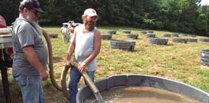
In 1963, the University obtained land classified as surplus property from the federal government and turned it into what is now the Tyson Research Center, a 2,000-acre field station near the Meramec River, just outside the St. Louis metropolitan area. In 1974, a sizable portion of Tyson was included in the Beaumont-Tyson Quarry District, a 44-square mile area listed in the National Register of Historic Places. This designation derives from the presence of an estimated 6,000-10,000 chert quarries along the ridge tops in the district. Tyson is managed by WUSTL and is available for research and environmental studies (such as the biodiversity and ecosystem study above that used 300-gallon water tanks to simulate small pond communities). Part of the Organization of Biological Field Stations network, Tyson is also used for educational and other activities by researchers and approved outreach groups. Oak-hickory forest covers about 85 percent of the hilly, karst-dominated landscape that is home to many varieties of ferns, mushrooms, wildflowers, and other plants and trees. While bears, mountain lions and elk can no longer be found at Tyson, deer, coyotes, foxes, bobcats, bats and other mammals remain. Bird-watching is a popular activity at Tyson, as is looking for butterflies and dragonflies.